Modules
The NMEA engine of NMEAremote is based on Sources and Modules.
As sources are delivering the messages e.g. from the boat’s network, the modules will handle the appropriate messages and assign their values to the module’s Properties.
In short a module is a group of related Properties.
Further some properties will be calculated depending on other properties, like the true wind from apparent wind.
Some of the modules could exist multiple times like “Battery” or “Engine”.
These modules also have a name to be identified by the user and an Instance ID which has to match the instance of the NMEA messages.
Not all modules exist by default. To add missing or remove unused modules, head to “Settings/Modules” and tap on “Edit”.
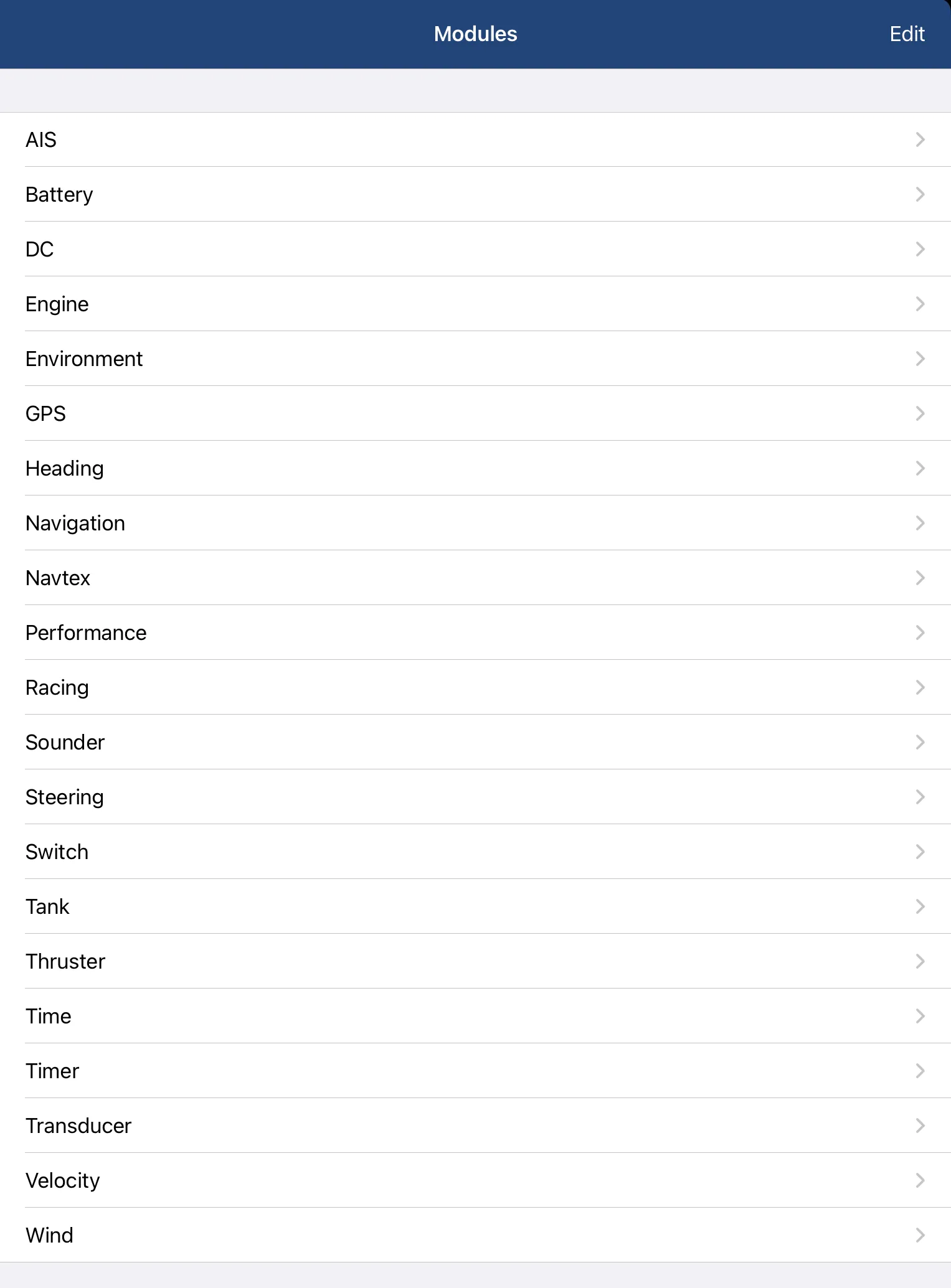
Overview of all modules and their properties:
If you are missing a module or certain properties, please let me know. Sometimes they are already on my to-do list or could easily be added, as I’m always open to improving NMEAremote.
Because of the generic approach of NMEAremote it is also possible to add custom modules and properties by a JSON config file.
AIS*
| Property | Description |
|---|
| Targets | List of received targets |
| CD | Closest Distance |
| TCPA | Time to Closest Point of Approach |
| DCPA | Distance to Closest Point of Approach |
| BCR | Bow Crossing Range |
| BCT | Bow Crossing Time |
Battery*
| Property | Description |
|---|
| Name | Assignable name |
| Instance ID | Matching NMEA-Instance |
| VOLT | Voltage |
| AMP | Current |
| PWR | Power |
| TEMP | Battery Temperature |
| SOC | State Of Charge in % |
| SPENT | Spent Capacity |
| Rem. CAP | Remaining Capacity |
| Rem. TIME | Remaining Time |
| CAP | Capacity |
| VOLT | Nominal Voltage |
| Type | Battery-Type (Flooded Lead, Gel, AGM, LiFePO4) |
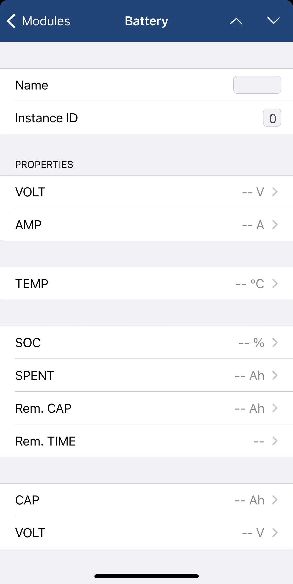
Sample of a Module Details View
DC Module*
| Property | Description |
|---|
| Name | Assignable name |
| Instance ID | Matching NMEA-Instance |
| VOLT | Voltage |
| AMP | Current |
| PWR | Power |
Engine*
| Property | Description |
|---|
| Name | Assignable name |
| Instance ID | Matching NMEA-Instance |
| RPM | Engine Revolutions |
| Max. RPM | Maximum RPM |
| ENGINE | Engine Temperature |
| BOOST | Boost |
| OIL PRESS | Oil Pressure |
| OIL TEMP | Oil Temperature |
| COOL PRESS | Coolant Pressure |
| FUEL PRESS | Fuel Pressure |
| FUEL | Fuel Rate in l/s, l/h or gph |
| ECO | Fuel Economy in km/l, NM/l, l/100km, mpg or NM/g |
| ECO ⌀ | Average Fuel Economy |
| FUEL USED | Fuel used |
| EGT | Exhaust Gas Temperature |
| ERT | Engine Room Temperature |
| TRIM | Trim in % |
| ALT | Alternator Volts |
| HOURS | Engine Hours |
| LOAD | Engine Load |
| TRQ | Engine Torque |
Environment
| Property | Description |
|---|
| Sea | Sea Temperature |
| Air | Air Temperature |
| Wave* | Wave Height |
| Set* | Current’s Direction |
| Drift* | Current’s Speed |
| BAR | Barometric Pressure |
| RH | Relative Humidity |
| AH* | Absolute Humidity |
| Dew* | Dew Point |
| Rain* | Precipitation Intensity |
| AD* | Air Density |
| Heat * | Heat Index |
| WCI* | Wind Chill Index |
| App Temp* | Apparent Temperature |
GPS
| Property | Description |
|---|
| POS | Position |
| LAT | Latitude |
| LON | Longitude |
| ALT | Altitude |
| COG | Course Over Ground |
| SOG | Speed Over Ground |
| Trend* | SOG Trend in % |
| Max. SOG | Maximum Speed Over Ground |
| Avg. SOG | Average Speed Over Ground |
| Trip* | Trip Over Ground |
| Log* | Log Over Ground |
| HDOP* | Horizontal Dilution of Precision |
| VDOP* | Vertical Dilution of Precision |
| PDOP* | Positional Dilution of Precision |
| Sat* | Satellites in View |
Heading
| Property | Description |
|---|
| HDG | Heading (TRUE if available otherwise MAG) |
| TRUE | True Heading (could use COG) |
| MAG | Magnetic Heading |
| DEV* | Deviation |
| VAR* | Variation |
| LEE* | Leeway |
| DRIFT* | Current Drift Angle |
| AOA* | Angle Of Attack (Current’s direction relative to boat) |
| HEEL* | Roll / Heel |
| TRIM* | Pitch / Trim (Fore-Aft) |
| ROT* | Rate Of Turn |
Navigation
| Property | Description |
|---|
| WP* | Waypoint Position |
| WP Name | Waypoint Name |
| ROUTE* | Current Route |
| BTW | Bearing to Waypoint |
| DTW | Distance to Waypoint |
| XTE | Cross Track Error |
| CTS* | Course to Steer |
| HE* | Heading Error (HDG-CTS) |
| RTW* | Relative Bearing To Waypoint (BTW-HDG) |
| TKE* | Track Angle Error (COG-BTW) |
| VMC* | Velocity Made Good to Waypoint |
| TTG | Time To Go |
| ETA* | Estimated Time of Arrival |
Navtex*
| Property | Description |
|---|
| Messages | List of received Navtex messages |
| Property | Description |
|---|
| VMG | Velocity Made Good |
| Polar | Polar File |
| Polar SPD | Polar Speed |
| Polar SPD % | Current Speed in % of Polar Speed |
| Polar HEEL | Polar Heel Angle (Expedition) |
| Polar HEEL % | Current Heel Angle in % of Polar Heel |
| Target TWA | Target True Wind Angle (either Beat TWA or Run TWA) |
| Target AWA | Target Apparent Wind Angle (either Beat AWA or Run AWA) |
| Target-TWA | Difference between Target TWA and TWA (True Wind Angle) |
| Target SPD | Target Speed (either Beat SPD or Run SPD) |
| Target SPD % | Current Speed in % of Target Speed |
| Target VMG | Target Velocity Made Good in kts. (either Beat VMG or Run VMG) |
| Target VMG % | Current VMG in % of Target VMG |
| Target HEEL | Target Heel Angle (either Beat or Run) |
| Target HEEL % | Current Heel Angle in % of Target Heel |
| Track | Course Over Ground of Opposite Track |
| Beat TWA | True Wind Angle for best VMG when sailing upwind |
| Beat AWA | Apparent Wind Angle for best VMG when sailing upwind |
| Beat SPD | Speed at best VMG when sailing upwind |
| Beat VMG | Best Velocity Made Good when sailing upwind |
| Beat HDG | Heading for best VMG when sailing upwind |
| Beat Port | Beat on Port Tack |
| Beat Stb. | Beat on Starboard Tack |
| Tack | Heading after tacking from Beat |
| Run TWA | True Wind Angle for best VMG when sailing downwind |
| Run AWA | Apparent Wind Angle for best VMG when sailing downwind |
| Run SPD | Speed at best VMG when sailing downwind |
| Run VMG | Best Velocity Made Good when sailing downwind |
| Run HDG | Heading for best VMG when sailing downwind |
| Run Port | Run on Port Tack |
| Run Stb. | Run on Starboard Tack |
| Gybe | Heading after gybing from Run |
| LAY | Bearing on Layline |
| LAY Port | Bearing on Port Layline |
| LAY Stb. | Bearing on Starboard Layline |
| DTL | Distance to Layline |
| DTL Port | Distance to Port Layline |
| DTL Stb. | Distance to Starboard Layline |
| TTL | Time to Layline |
| TTL Port | Time to Port Layline |
| TTL Stb. | Time to Starboard Layline |
| Polar VMC | VMC to waypoint at current heading based on polar, TWA & TWS |
| Polar VMC % | Current VMC as percentage of Polar VMC |
| Opt. VMC | Optimum VMC to current mark with a given polar and wind |
| Opt. VMC % | Current VMC as percentage of Opt. VMC |
| Opt. VMC HDG | Heading to achieve the optimum VMC to current mark |
| Opt. VMC TWA | TWA sailing the optimum VMC heading |
Racing*
| Property | Description |
|---|
| PIN | Position of Start Pin (start line port end) |
| RC | Position of Race Committee (start line starboard end) |
| BSL | Bearing of Start Line |
| LSL | Length of Start Line |
| SQR | Start Line Square Wind |
| BIAS | Bias of the Start Line in % |
| BIAS | Bias of the Start Line in m or ft |
| DTS | Distance To Start Line |
| BTS | Bearing To Start Line |
| TTS | Time To Start Line |
| Burn | Time To Burn (Countdown – Time To Start Line) |
| DTS PIN | Distance To Start Line Pin (Port End) |
| BTS PIN | Bearing To Start Line Pin (Port End) |
| TTS PIN | Time To Start Line Pin (Port End) |
| DTS RC | Distance To Start Line Race Committee (Starboard End) |
| BTS RC | Bearing To Start Line Race Committee (Starboard End) |
| TTS RC | Time To Start Line Race Committee (Starboard End) |
| BRG* | Bearing on Next Leg |
| DST* | Distance of Next Leg |
| Target SPD* | Target SPD of Next Leg |
| TTG* | Time To Go on Next Leg |
| TWA* | TWA on Next Leg |
| AWA* | AWA on Next Leg |
| AWS* | AWS on Next Leg |
Rig*
| Property | Description |
|---|
| FORESTAY | Forestay Load |
| FORESTAY | Forestay Length |
| BACKSTAY | Backstay Load |
| BOBSTAY | Bobstay Load |
| INFSTY | Inner Forestay Load |
| INFSTY | Inner Forestay Length |
| V0 Port & Stb | Shrouds V0 Port & Starboard |
| V1 Port & Stb | Shrouds V1 Port & Starboard |
| D0 Port & Stb | Shrouds D0 Port & Starboard |
| D1 Port & Stb | Shrouds D1 Port & Starboard |
| FURL | Jib Furl Torque |
| MAIN H | Main Halyard Load |
| JIB H | Jib Halyard Load |
| INFSTY H | Inner Forestay Halyard Load |
| SPI Port & Stb | Spinnaker Halyard Port & Starboard Load |
| MAIN | Mainsheet Load |
| VANG | Boom Vang Load |
| CUN | Cunningham Load |
| OUT | Outhaul Load |
| TRV | Traveller Position |
| JIB D | Jib Downhaul Load |
| RUNNER Port & Stb | Runner Port & Starboard Load |
| DFL Port & Stb | Deflector Port & Starboard Load |
| DFL Upper & Lower | Deflector Upper & Lower Load |
| MAST ANG | Mast Angle |
| MST RAKE | Mast Rake |
| MST CANT | Mast Cant Angle |
| MST BASE | Mast Base Load |
| MST BASE 2 | Mast Base 2 Load |
| BOOM ANG | Boom Angle |
| WIN Port & Stb | Winch Port & Starboard Load |
| LOAD 1 & 2 | Load 1 & 2 |
Rudder*
| Property | Description |
|---|
| Name | Assignable name |
| Instance ID | Matching NMEA-Instance |
| Rudder | Rudder Angle |
Sounder
| Property | Description |
|---|
| DPT | Depth |
| Trend* | Depth trend in % |
| Min. DPT* | Minimum Depth |
| Max. Depth* | Maximum Depth |
Tank*
| Property | Description |
|---|
| Name | Assignable name |
| Instance ID | Matching NMEA-Instance |
| CAP | Capacity |
| LVL | Level |
| VOL | Volume |
| Type | Type of Tank (Fuel, Oil,….) |
Thruster*
| Property | Description |
|---|
| Name | Assignable name |
| Instance ID | Matching NMEA-Instance |
| Location | Bow/Stern |
| RPM | Revolutions Per Minute |
| RPM % | Current RPM in % of RPM Max. |
| RPM Max. | Maximum RPM |
| TEMP | Temperature |
| CURRENT | Thruster Current in Ampere |
| PWR | Thruster Power in kW |
| HOURS | Operating Hours |
Time
| Property | Description |
|---|
| UTC | UTC Time |
| Local | Local Time |
| Timezone | Timezone Offset |
| Dawn* | Nautical Dawn |
| Rise* | Sunrise |
| Noon* | Local Apparent Solar Noon |
| Set* | Sunset |
| Dusk* | Nautical Dusk |
| Day* | Day Length |
| Phase* | Moon Phase |
| JD* | Julian Day |
| LMST* | Local Mean Sidereal Time |
| EOT* | Equation Of Time |
| Moment* | A moment is the 1/40th of a solar hour, which is 1/12th of sunrise to sunset. |
Timer*
| Property | Description |
|---|
| Name | Assignable name |
| Instance ID | |
| Time | Duration |
| Start | Start Time |
| Mode | Timer / Countdown |
Transducer
This is a generic module which has no default properties.
All transducer data received with the XDR sentence will be assigned to this module.
Velocity
| Property | Description |
|---|
| SPD | Speed Through Water in kts, m/s, km/h, mph or s/NM (ORC) |
| Trend | Trend of Speed in % |
| Max. SPD | Maximum Speed Through Water |
| Avg. SPD | Average Speed Through Water |
| Trip* | Trip Through Water |
| Log* | Log Through Water |
Vessel*
| Property | Description |
|---|
| Name | Vessel name |
| MMSI | MMSI (Maritime Mobile Service Identity) of the vessel |
| Call Sign | Call sign of the vessel |
Wind
| Property | Description |
|---|
| AWA | Apparent Wind Angle |
| AWS | Apparent Wind Speed |
| Max. AWS* | Maximum Apparent Wind Speed |
| TWA* | True Wind Angle |
| TWS* | True Wind Speed |
| Trend* | Trend of True Wind Speed in % |
| Max. TWS* | Maximum True Wind Speed |
| TWD | True Wind Direction (relative to north) |
| BFT | Beaufort |
| CWC* | Crosswind Speed |
* only in full version available

